//
For internal use only

Not On Display
Map (Chart)
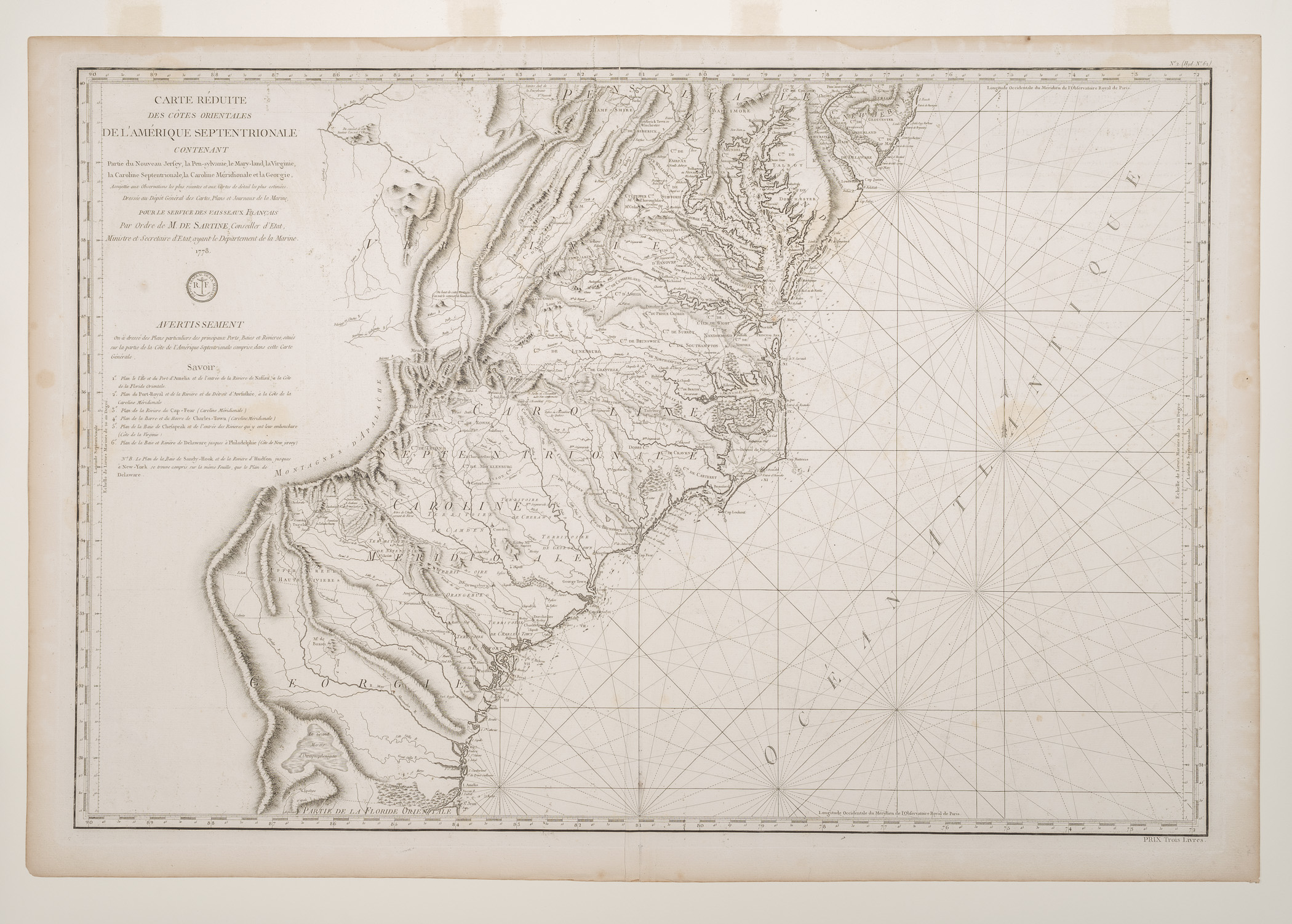
CARTE RÉDUITE/ DES CÔTES ORIENTALES/ DE L'AMÉRIQUE SEPTENTRIONALE/ CONTENANT/ Partie du Nouveau Jersey, la Pen-sylvanie, le Mary-land, la Virginie,/ la Caroline Septentrionale, la Caroline Méridionale et la Georgie,/ Assujettie aux Observations les plus récentes et aux Gartes de détail les plus estimées./ Dresée au Dépôt Général des Cartes, Plans et Journaux de la Marine,/ POUR LE SERVICE DES VAISSEAUX FRANÇAIS/ Par Ordre de M. DE SARTINE, Conseiller d'Etat,/ Ministre et Secretaire d'Etat, ayant le Départment de la Marine./ 1778.
M. de la Sartine
1778
Category
Prints and Maps
Creator/Artist/Maker
M. de la Sartine (Publisher)
Place of Origin
Paris; France; Europe
Materials
- Ink
- Paper (laid)
Museum Object Number
1984.0022
Credit Line/Donor
Museum purchase
Share Object
Complete Details
Object Number
1984.0022
Object Name
Map (Chart)
Title
CARTE RÉDUITE/ DES CÔTES ORIENTALES/ DE L'AMÉRIQUE SEPTENTRIONALE/ CONTENANT/ Partie du Nouveau Jersey, la Pen-sylvanie, le Mary-land, la Virginie,/ la Caroline Septentrionale, la Caroline Méridionale et la Georgie,/ Assujettie aux Observations les plus récentes et aux Gartes de détail les plus estimées./ Dresée au Dépôt Général des Cartes, Plans et Journaux de la Marine,/ POUR LE SERVICE DES VAISSEAUX FRANÇAIS/ Par Ordre de M. DE SARTINE, Conseiller d'Etat,/ Ministre et Secretaire d'Etat, ayant le Départment de la Marine./ 1778.
Category
Prints and Maps
Creator (Role)
M. de la Sartine (Publisher)
Place of Origin
Paris; France; Europe
Date
1778
Mark/Signature/Inscription/Label
Type: Inscription
Location: Upper left, near end of title
Inscription: ...Par Ordre de M. DE SARTINE,...
Type: Inscription
Location: Upper left, below title
Inscription: Circular seal of the "DEPOT GENERAL DE LA MARINE"
Mark/Signature: Yes
Materials
- Ink
- Paper (laid)
Techniques
- Etched
- Engraved
Dimensions (inches)
25.4 (H) x 37.07 (W) x 23 (Image H) x 34.13 (Image W)
Dimensions (centimeters)
64.4 (H) x 94.2 (W) x 58.4 (Image H) x 86.69 (Image W)
Measurement Notes
H at left. W at bottom. Plate H (at left): 23.875 in. (60.64 cm). Plate W (at bottom): 35.0 in. (89.0 cm).
Publisher Summary
de la Sartine
Publisher Date
01/01/1778
Place of Publication
Paris, France, Europe
Publisher Name
de la Sartine
Edition Watermark
Center right (inverted): Spreadwing bird with head facing towards center of paper; center left: "C (heart) F II[?]T"
Edition Notes
1778 edition of this combination map and sea chart was issued by the French Government and published as map 62 in L'Hydrographie Français, vol. 2 (Paris: 1778) for use by French Naval officers during the Revolutionary War. Other copies of this map date from 1737 to 1807, with the early maps attributed to cartographer and hydrographer Jacques Nicolas Bellin (1703-72) and engraved by Pettit.