//
For internal use only

Not On Display
Map (Line engraving)
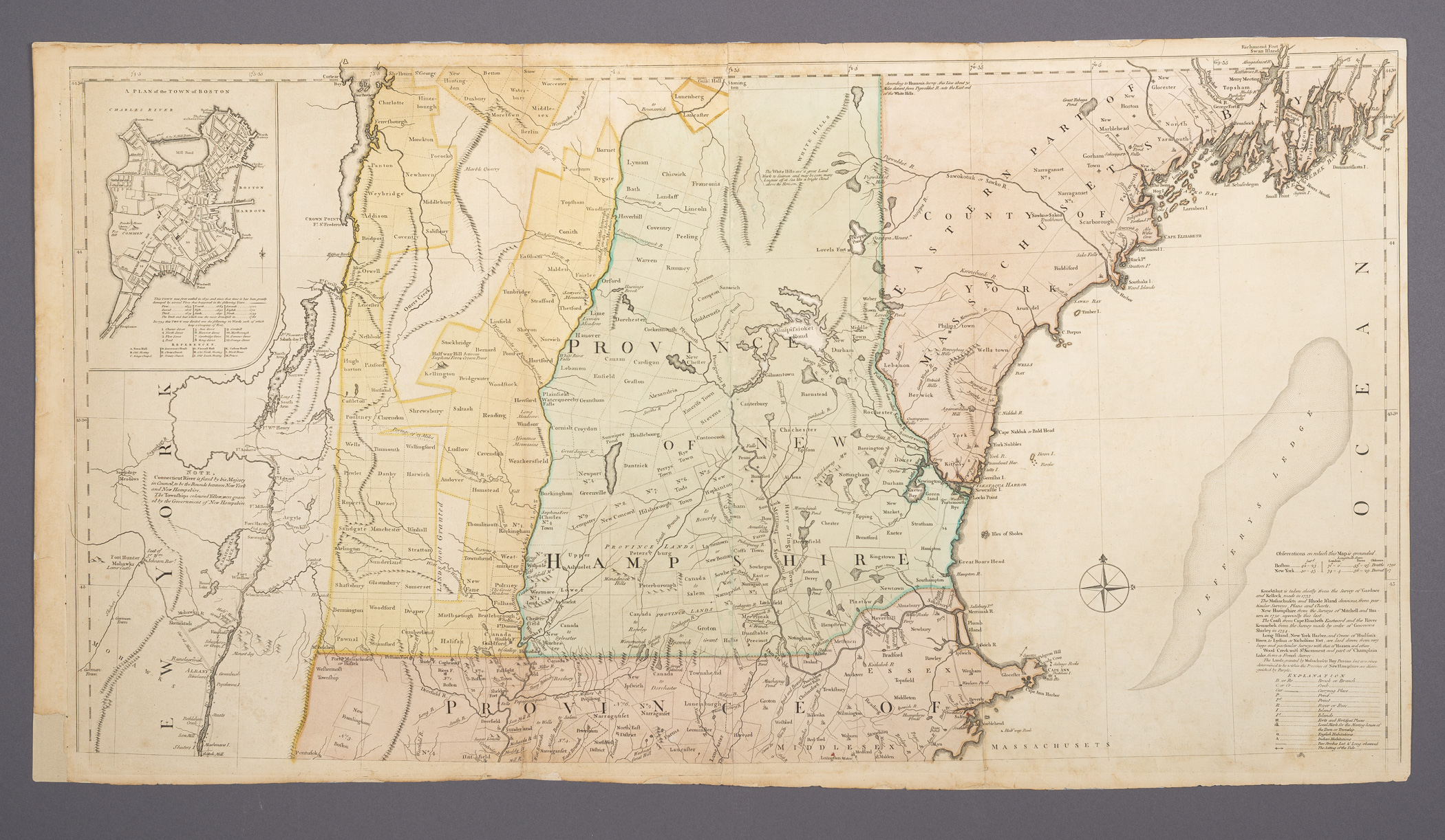
A MAP of/ the most INHABITED part of/ NEW ENGLAND/ containing the PROVINCES of/ MASSACHUSETTS BAY and NEW HAMPSHIRE,/ with the COLONIES of/ CONECTICUT and RHODE ISLAND,/ Divided into Counties and Townships:/ The whole composed from Actual Surveys and its Situation adjusted by_/ ASTRONOMICAL OBSERVATIONS.
Thomas Jefferys, Braddock Mead
November 29 1774 (1774-1774)
Category
Prints and Maps
Creator/Artist/Maker
Thomas Jefferys (Geographer and publisher)
Place of Origin
London; London; England; United Kingdom; Europe
Materials
- Ink
- Watercolor
- Paper (wove)
Museum Object Number
1974.0169 A, B
Credit Line/Donor
Museum purchase
Share Object
Complete Details
Object Number
1974.0169 A, B
Object Name
Map (Line engraving)
Title
A MAP of/ the most INHABITED part of/ NEW ENGLAND/ containing the PROVINCES of/ MASSACHUSETTS BAY and NEW HAMPSHIRE,/ with the COLONIES of/ CONECTICUT and RHODE ISLAND,/ Divided into Counties and Townships:/ The whole composed from Actual Surveys and its Situation adjusted by_/ ASTRONOMICAL OBSERVATIONS.
Category
Prints and Maps
Creator (Role)
Thomas Jefferys (Geographer and publisher); Braddock Mead (Cartographer)
Place of Origin
London; London; England; United Kingdom; Europe
Date
November 29 1774 (1774-1774)
Mark/Signature/Inscription/Label
Type: Inscription
Location: Bottom right on (b)
Inscription: November 29.\th 1774. Published according to Act by Tho.\s Jefferys Geographer to His Royal Highness the Prince of Wales near Charing Cross
Mark/Signature: Yes
Subject(s)
- Allegory
- Historical
- American Indian
- Native American
Materials
- Ink
- Watercolor
- Paper (wove)
Techniques
- Etched
- Engraved
- Hand colored
- Painted
Construction Description
Printed with four plates on four sheets of laid paper, joined in pairs vertically to form the northern and southern parts.
Dimensions (inches)
21.6 (H) x 40.1 (W) x 20.7 (Image H) x 38.5 (Image W)
Dimensions (centimeters)
54.9 (H) x 101.8 (W) x 52.5 (Image H) x 97.9 (Image W)
Measurement Notes
Measurements above of (a). H at left (past torn corner). W at bottom (above torn corner). Plate H (near left): 21.0 in. (53.4 cm). Plate W not available.
Measurements of (b). H at left (past torn corner): 21.6 in. (54.9 cm). W at top: 39.4 in. (100.0 cm). Plate H (near left): 21.1 in. (53.7 cm). Plate W not available. Image H: 20.4 in. (51.8 cm). Image W: 38.48 in. (97.74 cm).
Chain interval: 2.7 cm; laid lines per cm not measured.
Publisher Summary
T. Jefferys
Publisher Date
11/29/1774
Place of Publication
Charing Cross, London, England, United Kingdom, Europe
Publisher Name
T. Jefferys
Edition State
I
Edition Watermark
(a) countermark at center on left and right sheets (sideways): "VI" (facing opposite directions) ; (b) center on left sheet (sideways): fleur de lis surmounted by a crown with the letters "LVG" below, countermark at center on right sheet (sideways): "IV"
Coloring
Hand colored with transparent and opaque watercolors
Edition Notes
Third edition. First published in 1755. The only change in this edition from the second state of the second edition (c. 1768) is the imprint. Published in Thomas Jefferys, The American atlas (London: Robert Sayer and John Bennett, 1776 (dated 1775), 1777 (dated 1776), 1778, and 1782), and in William Faden, The North American atlas (London: William Faden, 1777).